Geophysics at Brezhani
Petar Zidarov
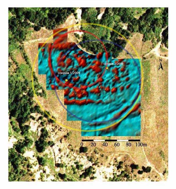
In 2010, a team comprising a few archaeologists – namely M. Grębska-Kulow and I. Kulov (then RHM-Blagoevgrad), P. Zidarov (then NBU) and students from New Bulgarian University and Southwestern University in Blagoevgrad – set off to carry out geomagnetic surveys at the hard-to-reach prehistoric site in Raven locality, near the village of Brezhani hoping to find out about the boundaries of the inhabited area and the planigraphic organization of the archaeological features. Geomagnetic measurements were carried out using a cesium magnetometer (Geometrics G-858), along profiles spaced one meter apart and oriented along the axis of the square grid of the previous excavations. The measurements cover a total area of approx. 2 ha. The resulting magnetic map seemingly offered the first (until then) comprehensive plan of an Early Neolithic settlement in SW Bulgaria. It revealed traces of localized anomalies organized in parallel rows and surrounded by several concentrically located linear anomalies each of an oval shape. The presence of burned buildings near the surface, revealed by the earlier test trenches, offered solid reasons to assume that the staggered zones with enhanced magnetic intensity should reflect the location of the burned buildings from the uppermost Neolithic horizon. The concentric linear anomalies can be interpreted as indications of multiple enclosures consisting of ditches and ramparts, which could date to different construction phases or even different age altogether. The magnetic map also clearly documents that the northern part of the site has already been destroyed through the erosion of the southern bank of the Brezhanska River, while the isolated segment of a linear feature to the NW shows that there could have been an older and smaller enclosure during the earlier phase of the occupation.
Bibliography
Grębska-Kulow, Zidarov 2010: Гребска-Кулова, М., and П. Зидаров. 2011. “Недеструктивни проучвания на раннонеолитно селище в м. Равен, при с. Брежани, общ. Симитли.” Археологически открития и разкопки през 2010 г.:41–3.
Geophysics at Drenkovo II
Petar Zidarov
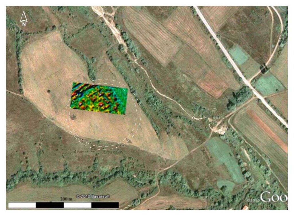
In 2010 and then again in 2012, following the successful application of magnetometry at Brezhani, the same core team consisting of Petar Zidarov, M. Grębska-Kulow and I. Kulov, also now assisted by N. Prahov (now CUA-Sozopol), Z. Rujak (Zavod and Museum Strumica, North Macedonia), E. Kanzurova (Museum of Macedonia in Skopje, North Macedonia) and students from New Bulgarian University and Southwestern University in Blagoevgrad, conducted two surveys at another Neolithic site in Blagoevgrad region known as Drenkovo-Garleshki Nivi or Drenkovo II.
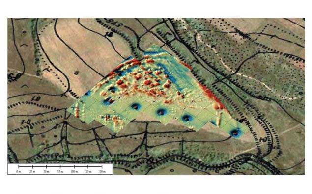
The 2010 survey lasted for only three days at the end of October, and was interrupted by harsh weather conditions. The measurements in 2010 covered a total area of approx. 0.5 ha (50x100m), though limited by thick vegetation and the iron elements of the local irrigation system. The resulting magnetic map seemingly offered another comprehensive plan of a portion of an Early Neolithic settlement defined through areas of enhanced magnetic values organized along parallel rows and surrounded by segments of two concentric linear anomalies of an oval shape to the north-west of the surveyed perimeter. The presence of burnt daub pieces in the ploughzone, offer solid reasons to assume that the zones with enhanced magnetic intensity should indicate the location of the burned buildings from the uppermost Neolithic horizon. Similarly to Brezhani the concentric linear anomalies characterized by contrasting magnetically enhanced and depleted values around them can be tentatively interpreted as indications of multiple enclosures consisting of ditches and ramparts.
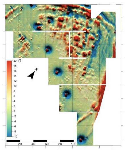
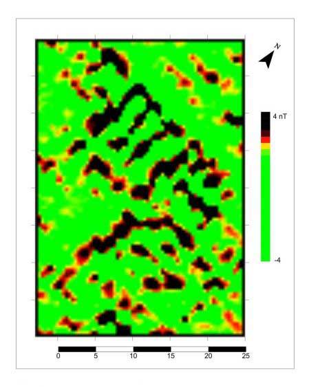
Following this promising pilot study, the team returned to the site in 2012 to survey a greater area in order to define its boundaries and planigraphy. The most relevant results of the new magnetogram confirmed the identification of the two major kind of features: the first – rows of distinct spatial anomalies confined by the second – curvilinear concentric features. This situation could be interpreted as burnt buildings enclosed by ditch and rampart, and reinforced by two parallel ditches to the N/NW and a single one to the E/SE. The linear and curvilinear anomalies seem to be interrupted along the east-west axis by what seems like entrances from the east and west. The average diameter of the enclosed space at Drenkovo is ca. 170m, adding to ca. 2ha large enclosure. In 2012 the team tried to estimate the likely dimensions of its ditches using series of hand-driven auger drill samples (0.1m in diameter) across the linear anomalies. These cut across thick layers of burnt daub, but due to the restricted sample size, it could not be determined whether they belong to a house, or a palisade burnt in situ or whether such ruins were used to backfill and level some of the ditches.
Bibliography
Grębska-Kulow, Zidarov 2011: Гребска-Кулова, М., П. Зидаров. “Недеструктивни проучвания на раннонеолитно селище в м. Гърлешки ниви, край с. Дренково, община Благоевград.” Археологически открития и разкопки през 2010 г.:43–45.
Grębska-Kulow, Zidarov 2013: Гребска-Кулова, М., П. Зидаров. “Теренни проучвания на праисторическото селище Дренково-Гърлешки ниви, община Благоевград.” Археологически открития и разкопки през 2012 г.:45–47.