Geological setting of the region, and mineralogical and petrographical composition of artefacts
Ruslan I. Kostov
Geological setting of Brezhani
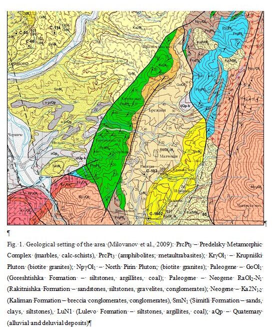
The area of and around the settlement of Brezhani falls in the north-western parts of the foothills of the Pirin Mountains. From a geotectonic point of view, it is located on the fault line of the same name, and within the limits of the so-called “Brezhani Graben”. One of the most serious earthquakes within the territory of the country since the beginning of the 20th century was the Krupnik earthquake of 1904, which happened in the area of Krupnik. From a geological point of view, the studied area is located on the Oligocene-Neogene sediments. The area of the settlement is crossed by two rivers – to the north the Goryaschitsa River, and to the south – the Brezhanska River. In their upper reaches their riverine geologies are fed by various types of granitoids of the North Pirin Pluton – fine-grained and medium to coarse-grained biotite granites (Marinova, Zagorchev, 1990; 1993). Then following along the course of the Goryaschitsa River, the geology comprises mainly marbles, calcareous schists, biotite gneisses and gneisses from the Predel Metamorphic Complex, and near the Brezhani River, conglomerates and sandstones dating from the Lower Miocene period. In the area of the settlement, sedimentary rocks of the Paleogene-Neogene period (Upper Oligocene – Lower Miocene) are exposed, represented by sandstones, siltstones, gravelites and conglomerates. Bituminous rocks and coal occurrences are known in the Oligocene sediments. Near the settlement, the “Pirin” coal mine, which closed at the beginning of the 21st century, had been operating since 1925. In the westerly direction, the river beds pass through a metamorphic strip of the Predel Metamorphic Complex, exposed in a north-south direction, with a width of up to 500m. Here the geology is represented by amphibolites, amphibole gneisses and metaultrabasic rocks (Marinova, Zagorchev, 1993; Milovanov et al., 2009). Further to the west, towards the Struma River, a variety of Neogene and Quaternary sedimentary rocks are revealed represented mainly by sands, clays and siltstones. The indicated rocks immediately around the settlement and the beds of the two rivers are the most likely and possible source of raw materials for the manufacture of prehistoric stone tools.
Geological setting of Drenkovo
This settlement, with a small river passing through it, is located on Upper Eocene sedimentary rocks represented by thick-bedded sandstones, gravelites, siltstones and conglomerates of the Logodash Formation (Zagorchev, Ruseva, 1990; 1993; Milovanov et al., 2008). The river with its surrounding tributaries is fed to the west and north by metamorphic rocks of the Frolosh Metamorphic Complex, represented mainly by actinolite-bearing and epidote-amphibole schists and metagabbro, and to the west by carbonate limestone rocks and red quartz conglomerates and sandstones dating to the Triassic period. Two types of mica and biotite gneisses and slates from the Maleshevski Metamorphic Complex are exposed in the easterly direction (Milovanov et al., 2008). The indicated rocks which outcrop around the settlement and in the beds of the near-by rivers are the most likely and possible source of raw materials for the manufacture of prehistoric stone tools.
References
Zagorchev, I., M. Ruseva. 1990. Geological Map of the Republic of Bulgaria. 1:100000. Kriva Palanka and Kyustendil. Committee on Geology; Enterprise for Geophysical Surveys and Geological Mapping (in Bulgarian).
Zagorchev, I., M. Ruseva. 1993. Explanatory Note. Geological Map of Bulgaria 1:100000. Map Sheets Kriva Palanka and Kyustendil. Sofia, Geology and Geophysics AD; GI BAN, 75 p. (in Bulgarian)
Milovanov, P., I. Klimov, V. Zhelev, D. Sinovski, V. Valev, I. Petrov, E. Ilieva. 2008. Geological Map of the Republic of Bulgaria 1:50000. K-34-70-G (Vaksevo). Ministry of Environment and Water; Bulgarian National Geological Survey (in Bulgarian).
